Sunday, 1 March 2015

Brân - Celtic god of Hades

Brân fab Llyr/Bendigeidfran is the central character of the Second Brânch of the Mabinogi, which traditionally bears the name of his sister, Brânwen ferch Llyr. Brân Bendigeid, “Blessed Raven” is a Celtic sea-deity, the son of Llyr, associated with the early Celtic cult of the head and and possibly with the Morrigan, the goddess of battle, strife, and sovereignty who also appears in the form of a crow. The Morrigan can appear as both a single goddess and as a trio of deities with Badb (Crow), and either Macha (also Crow) or Nemain (Frenzy). There is ample evidence that the concept of a raven goddess of battle was not limited to the Irish Celts.

In the Mabinogi
In the distant mythological past, Brân is a giant and king of Britain. His sister Brânwen is betrothed to Matholwch, king of Ireland. Matholwch is insulted when his horses are mutilated so Brân presents a gift of a magic cauldron to the Irish king. Matholwch takes Brânwen back to Ireland with him. When Brân hears Brânwen is being mistreated by her husband’s people he musters the hosts of Britain for an expedition to Ireland. He leaves his son Caradawg as officer in charge of the Island of the Mighty while he embarks to Ireland.

In the bloody war that ensues, Irish warriors are revived by being thrown into the peir dadeni (cauldron of rebirth) resurrected but without the power of speech. Ultimately Brân succeeds in rescuing Brânwen but in the midst of the fighting, there is an obscure traditional utterance in which Brân is called 'Morddwyd Tyllion' this is clear reference to his fatal wound (pierced thighs). The fighting ends when the Irish and the army of the Island of the Mighty have all but annihilated each other; only seven of Brân's party survive and return to Harlech. He tells his followers how to deal with the situation by decapitating him:

‘And take the head,’ he said, ‘and bring it as far as the
White Mound (Gwynfryn) in London, and bury it
with its face towards France. And you will be a long
while on the way. In Harlech you will be seven years
engaged in feasting, with the birds of Rhiannon
singing above.’

The following 87-year Otherworldly feast is referred to in the tale by the peculiar traditional name 'yspydawt urdawl benn' (hospitality of the noble head), during which Brân’s head remains alive, uncorrupted, and as good a companion as ever. The Otherworld feast comes to an end when one of Brân’s retinue opens the door facing south, towards Cernyw (Cornwall) and Aber Henfelen. They must now end their sojourn in the Otherworld, take the head  and bury it at the White Mound. The Third Brânch (the Mabinogi of Manawydan), opens with Brân’s head interred as a talisman preventing the incursion of foreign oppression.

It is evident from the Mabinogi account that Brân is a supernatural figure; his head has the ability to live on after its decapitation; it talks, sings and can prophesy to its companions in an Otherworldy feast that lasts 87 years.

In the Book of Taliesin
In the Second Brânch tale, Taliesin is named as one of the seven who returned from Ireland with Brân’s head. Among the mythological poetry in Llyfr Taliesin, in the poem Song Before the Sons of Llyr, there are allusions to two episodes in Brân’s story which interestingly use the same words as the Mabinogi tale:

A battle at the feast over joyless beverage,
A battle against the sons of Llyr in Ebyr Henfelyn. 

I have been with Brân in Ireland.
I saw when Morddwydtyllon was killed 

Complete is my chair in Caer Siddi,
No one will be afflicted with disease or old age that may be in it.
Manawyddan and Pryderi know it  

The narrator, Taliesin, was one of the seven survivors named along with Manawyddan, Pryderi, and four others in the Mabinogi of Brânwen. Clearly, the poem and the tale of Brânwen are closely related texts, referring to the same event, confirming the old and traditional status of elements of the Mabinogi text.

In the Welsh Triads 
The burial of Brân’s head is recorded in the Triads of the Island of Britain (Trioedd Ynys Prydein) as one of the Three fortunate concealments of the Island of Britain. The following translation is based on the Red Book version (Llyfr Coch Hergest):

The head of Bendigeidfran son of Llyr, which was
concealed in the White Hill in London, with its
face towards France; and so long as it remained as it
was laid there, no Saxon oppression (gormes) would
ever come to this island. 

Brân's severed head is also described as one of Three Unfortunate Disclosures because Arthur declared that he needed no talisman to protect his own country and dug up the head. However, we are not told what he did with it.

In Ancient Greek History
Brân's story is well known in traditional accounts, as we have seen, featuring in the Mabinogi, The Book of Taliesin and the Triads of the Island of Britain. John Koch has equated Brân's story with the famous historical Gaulish chieftain Brennos (Brennius), together with Akichorios, who led a Celtic offensive in the Balkans and attacked Macedonia and Greece in the 3rd century BC.

At the beginning of 279 BC the Gaulish chieftain Bolgios’s army annihilated the detachment of the Macedonian ruler Ptolemy Keraunos, opening the way into Greece for Brennos to follow with a force comprising 152,000 infantry and 20,000 cavalry. Brennos continued south. By the autumn of 279 BC he had reached and passed the strategic pass at Thermopylae. Brennos then attacked Delphi with 65,000 men. It seems the winter forced the Gauls to retreat; a miraculous snowstorm sent by Apollo saved the Delphic sanctuary from the onslaught of the Gauls. Brennos, gravely wounded, retreated to the north, where he rejoined Akichorios’s forces but, unable to stand the pain of his wounds, he took his own life by stabbing himself.

The episode of Brennos’s death has been compared with the voluntary beheading of the wounded Brân after the great invasion of Ireland in the Mabinogi; Diodorus Siculus (22.9) has the wounded Brennos command his surviving followers to kill him.

Some of the treasure taken from Delphi by Brennos’s Gauls was deposited, as an offering to their god, in the sacred pools of the Volcae Tectosages at Tolosa (Toulouse) in south-west Gaul. The treasure was then raised out of the ritual pools by the Roman general Caepio when the area was conquered in 106 BC, and considered comparable with the talismanic deposition of Brân’s severed head which protected Britain from foreign conquest.

In Medieval Welsh Legendary History
In Brut y Brenhinedd, the Welsh versions of the Historia Regum Britanniae of Geoffrey of
Monmouth, the legendary prehistoric British king called Hely by Geoffrey appears as Beli, and the
conquerors of Rome whom Geoffrey called Brennius and Belinus have the Welsh names Brân and Beli. However, Beli may derive from the Old Celtic name, which is attested as both Bolgios and Belgius, and was borne by the chieftain who led the Gauls’ invasion of Macedonia in 280–279 BC.

Another Brennos (of the Senones) was a Gaulish leader who marched at the head of assembled Celtic warbands c. 390 BC, that routed the Roman army eleven miles from Rome. The recurrence of the name Brennus raises the suggestion that it was a title rather than a proper name. However, the Welsh name Brân could be related to Gaulish Brennos, but is not its exact equivalent. Geoffrey probably saw the name 'Brennius' as a Latinisation of 'Brân' and muddled the two accounts.

The Raven
The story of Brân in the Mabinogi is well known for the 'talking head' episode when, after being fatally wounded, Brân orders his retinue to severe his head and take it with them. The head continues to talk and remains uncorrupted until one of the party break a taboo and open a window to the south. The head is then buried at Bryn-Gwyn, the White Mound, said to be the site of the Tower of London, however, the Tower's association with the raven is a late tradition. Nearby Tower Hill, described as the“blood-stained ground to the north-west of the Tower,” maybe a better candidate where there is archaeological evidence of a Bronze Age settlement and, later, the site of many public executions. According to Geoffrey the 'White Mound' is the burial place of Brutus.

There seems to have been a cult of the head at the site of St Paul's with numerous animal skulls found there when the building of the present cathedral began in 1675 AD, architect Sir Christopher Wren, discovered remains of a pagan Stag Goddess temple in the foundations of the previous Cathedral which had been destroyed in the Great Fire of London in 1666. This was possibly the site of the pagan temple at Ludgate Hill, reputedly destroyed by the Saxons in 597.

Koch suggests that the Roman Saxon Shore fort of Brâncaster in Norfolk, may have been the site of the original interment of Brân's head. Recorded in the Notitia Dignatatum under the Romano-British name as “Brânodunum” meaning the 'fort of Brân'. It seems more than coincidence that a fort of the litus Saxonicus should be named after a supernatural protector defending the land from foreign oppression (gormes) as reflected in the Triads; the White Mound in London would hardly be in the first line of defence against overseas invaders.`

Anne Ross informs us that birds and heads are associated with each other concerning the Irish war raven goddesses. In O'Mulconry's Glossary, from the Yellow Book of Lecan, the name of the goddess Macha is described as “a crow, or it is one of the three Morrigana. Mesrad Machae, Machae's Mast, that is the heads of men after their slaughter.” Ross adds that the heads of the dead would thus appear to be this bird-goddesses' due, i.e. the dead were more than just food for crows; the spirits of the fallen belonged to the Morrigana.

Koch has drawn attention to a similar reference in Y Goddodin. Crows and ravens feature heavily in Welsh poetry depictions of battlefields. This is typically seen as the act of consuming carrion but can equally imply the presence of a deity collecting souls of the fallen. Koch translates the following stanza (A.24) of Y Gododdin as:

The hero with the protective shield under its polychrome boss,
(with movement like a colt),
was tumult on slaughter's high ground, was fire,
His spears were readied, they were [like] the sun,
He was food for ravens, he was spoils for Brân.

The final line of this stanza makes it quite clear that the dead were not just food for carrion birds but the property of Brân; he was the Celtic god of Hades.

Koch adds that in pre-Christian times, Brennos functioned as the Brittonic god of death, comparable to the Irish Donn and the Dis Pater of the Gauls as reported by Julius Caesar. This supernatural role fits perfectly with Brân's living decapitation and the 87 year Otherworld feast of the noble head.

Significantly, in the Mabinogi of Brânwen the gathering in Ireland is referred to as Gwledd Brân, (The feast of Brân): there is strong argument for presenting Brân as a Celtic psychopomp, guiding the souls of the dead heroes of the battlefield to the glorious afterlife.


Copyright © 2015 Edward Watson
http://clasmerdin.blogspot.co.uk/


Sources:
Anne Ross, Celtic Pagan Britain, Academy Chicago, 1996.
Rachel Bromwich, Trioedd Ynys Prydein (The Triads of the Island of Britain), University of Wales Press, Third Edition, 2006.
Mary Jones, Celtic Literature Collective, Song Before the Sons of Llyr from Llyfr Taliesin (The Book of Taliesin).
John T. Koch, Brân, Brennos: an instance of Early Gallo-Brittonic history and mythology, Cambridge Medieval Celtic Studies (CMCS) 20, 1990.
John T. Koch, Celtic Culture, ABC-CLIO, 2006.
John T. Koch, The Gododdin of Aneirin: Text and Context from Dark-Age North Britain, Celtic Studies Publications, 1997.
Angelique Gulermovich Epstein, War Goddess: The Morrígan and her Germano-Celtic Counterparts (Dissertation).


* * *


Thursday, 5 February 2015

King Arthur's Great Hall Tintagel

After being disappointed at Tintagel Castle I wandered  down Tintagel high street into King Arthur's Great Hall of Chivalry thinking it was an Arthurian bookshop. Books it did have and plenty of them but nothing particularly rare or difficult to find elsewhere. A doorway off the shop leads into a long corridor adjoining a massive hall, an Arthurian work of art, a shrine to the King, funded and created by people who evidently loved the legend.

King Arthur's Great Hall of Chivalry
The Hall was formerly known as Trevena House, after the name of the village before it changed to Tintagel after the castle on the nearby peninsula, until it was purchased by Frederick Thomas Glasscock in 1928. The house was originally built on the site of the former Town Hall and Market Hall in Fore Street by J D Cook, born at Camelford and one time editor of the 'Morning Chronicle' and founder of the popular 'Saturday Review'. He visited Tintagel rich with its Arthurian memories and bold headland and ruined walls every summer during the 1860s and befriended the Vicar and Honorary Constable of the Castle, the Reverend Kinsman, who had taken a great interest in the island making it safer and more accessible to visitors, constructing a new path to the headland. It was largely due to Kinsman's interest that the island became a tourist attraction in the Victorian period. Cook died in 1868 and was buried under an immense white monument in the churchyard on the hill above Tintagel, as near the edge of the cliff as possible.

Glasscock was a wealthy business man who spent a small fortune adapting the Hall as a worthy monument to King Arthur and the Knights of the Round Table in the spirit of true romance. And it is a fitting monument indeed. It is said Glasscock employed local and Cornish workmen for the construction as far as possible, because of their love for the great King who once ruled over their land.

Corridor leading to the Great Hall
It became the headquarters for Glasscock's Order called the Fellowship of the Round Table which he founded in 1927 where brother knights were initiated into a chivalric system of medieval romanticism. The Fellowship was so successful that Glasscock had to increase the size of the Hall which opened in 1933 pretty much as we see it today.

It is claimed that over 50 types of Cornish stone were used in the Hall's construction, including slate, granite, greenstone, tourmaline, onyx, elvan and serpentine, brought here from places such as Rough Tor and Castle-an-Dinas on Bodmin Moor and others from the nearer Tintagel Castle.

Everything in the Hall is based on Arthurian Romance. There are 125 shields of granite, set along the full length of the Hall, said to represent the passage from darkness into light. The banners of the Knights are hung around the Hall

The Throne
There are thrones carved of solid oak carved with the emblems of insignia of King Arthur and his Queen Guenevere. Granite is also used in the huge six ton canopy over the throne, supported by nine massive granite pillars. There is also a granite Round Table, along with two wooden ones.

Ten paintings by William Hatherell R.I. on the walls depict the principal events in the story of King Arthur. It is suspected that Hatherell died in 1928 before he completed his Arthurian commission for Glasscock.  Hatherell depicted scenes from Malory's Morte D'Arthur such as the choosing of Arthur to be King; the gift to him of the great Sword Excalibur; the presentation of the Round Table; the achievement of the Sangreal; and of course, the passing of King Arthur.

The Great Hall
Veronica Whall, the daughter of Christopher Whall leader of the Arts and Crafts Movement 1880-1910, designed the 73 stained-glass windows in the Hall considered to be the largest collection of stained glass panels of King Arthur made in the 20th century. The large windows either end of the hall are reminiscent of the Pre –Raphaelite era and worthy of a great cathedral, referred to as the best post Pre – Raphaelite windows anywhere.

‘The Windows of the Knights’ show each Knight of the Round Table illustrated by his unique shield at each window where the Knight’s story is also told in words. The Hall has eighteen windows known as the 'Windows of Virtue', which portray the principal virtues which the Knights of the Round Table agreed to observe. The virtues are graded in quality, starting with the less spiritual ones such as Strength, Perseverance and Obedience, through to the more spiritual such as Purity, Faith and Love.


However, there appears to have been some discord between Glasscock and Whall when he apparently refused to pay the agreed price. This ended up in a court case, the strain of which affected the artist's health.

Glasscock extended his Fellowship to America but he died in 1934 on board the Queen Mary on a voyage to further promote his organisation. Glasscock had been a Freemason and bequeathed the Hall to his local lodge who still use it for meetings.

Stumbling upon this impressive Great Hall by accident made the visit to Tintagel worth it.


Copyright © 2015 Edward Watson
http://clasmerdin.blogspot.co.uk/


Sources:
Paul Broadhurst, Tintagel and the Arthurian Mythos, Pendragon Press, 1992.
King Arthur's Great Halls of Chivalry, The Sword in the Stone Ltd. (undated pamphlet)


* * *


Saturday, 31 January 2015

Tintagel Castle

Wave after wave, each mightier than the last,
Till last, a ninth one, gathering half the deep
And full of voices, slowly rose and plunged
Roaring, and all the wave was in a flame:
And down the wave and in the flame was borne
A naked babe, and rode to Merlin's feet,
Who stoopt and caught the babe, and cried "The King!
Here is an heir for Uther!"

Island of Disenchantment
Straddled across the windswept precipitous headland, Tintagel Castle is half on the mainland, half on the island, connected only by a narrow neck of land which has led to the popular acceptance that the origin of the name arises from Cornish Dintagel; 'Dun' meaning 'fort' with '-tagell' meaning 'narrow place'.

Suggestions that the source of the name is from 13th century Norman French at first glance seem absurd but Geoffrey of Monmouth's History of the Kings of Britain (Historia Regum Brittaniae) c.1136 AD contains the earliest written mention of Tintagel in the tale of how Arthur was conceived there when Uther Pendragon, King of Britain, magically assisted by Merlin of course, seduced Queen Igerna, the wife of Duke Gorlois of Cornwall. We have no idea why Geoffrey would have chosen Tintagel as the site of the conception but we do know that he placed much of his Arthurian 'history' in Cornwall.


There is little evidence of any occupation before the Dark Ages, various small finds, including pottery and some late 3rd and early 4th century Roman coins, suggest activity on the headland but nothing more. From around 450 AD to 650 AD Tintagel was a prosperous and highly significant site. Its position made it highly defensible and most unusually it also has supplies of fresh water.

So many steps....
C A Ralegh Radford's excavations in the 1930s identified the apparent pattern of scattered small-scale structures as buildings of a monastic enclosure; the remoteness of the headland would be an attractive site to those seeking isolation. Radford worked at the site again in the 1950s and found nothing to change his mind. Indeed, some of the pottery fragments bore Christian symbols, taken with the wider distribution of these types of imported pots they appear to match that of early Christian inscriptions. Fragments of imported high-quality Mediterranean pottery have been found all over western Britain, but Tintagel has by far the largest quantity so far discovered. The pottery along with  Mediterranean glassware is evidence of trade with lands as far away as ancient Byzantium, possibly in exchange for desirable Cornish tin.

This remained the accepted interpretation of Tintagel island until Archaeological excavations, commissioned by English Heritage, between 1990 and 1999 re-evaluated Radford's work and concluded that instead of a small community of Celtic monks, Tintagel may have been one of Western Britain’s premier centres of Dark Age political and military power.

Remains of the 13th century castle
Radford, along with Geoffrey Ashe, co-founded the Camelot Research Committee in the 1960s with like-minded individuals under the direction of archaeologist Leslie Alcock in an attempt to discover Arthurian sites such as Camelot. Ralegh Radford directed excavations at Glastonbury Abbey between 1951 and 1964, the infamous burial place of King Arthur; Alcock directed excavations at South Cadbury hillfort from 1966-70 publishing his interpretation of his findings in the book 'By South Cadbury Is That Camelot' (Thames & Hudson, 1972).

The pottery finds, combined with the buildings on the headland suggest intensive occupation at this period, often interpreted as a seasonal stronghold of the Kings of Dumnonia (Devon and Cornwall).
The  high-quality Mediterranean pottery has also been found at Cadbury Castle in Somerset, a favoured suggestion for Arthur's Camelot. Then suddenly the pottery imports stopped.

Dark Age remains near the summit
After the mid-7th century there is little evidence of activity on the Tintagel headland for the next 500 years. During the 13th century, a castle was built on the site by Richard, Earl of Cornwall, which later fell into disrepair and it is the ruins of these buildings that dominate views of the site today. Once past the 13th century curtain wall to the Great Hall courtyard you are at will to explore the Dark Age remains that are generally distinguished as low grass-covered banks over the top of the island. If you know where to look you will find King Arthur's Footprint immortalised in stone at the highest point of the island. Nearby is King Arthur's Seat a cleft in the cliff. The rock here bears a peculiar series of hollows known as King Arthur's Cup and Saucers.

In about 1480 the antiquary William Worcestre claimed Tintagel as the place of Arthur’s birth as well as his conception but the identification of Tintagel as King Arthur’s Castle is not found until 1650. However, by now Arthur's base was firmly established at Camelot, wherever that was, and Tintagel,with little activity, slipped into relative obscurity until a late revival in the Victorian Age and became a tourist attraction.

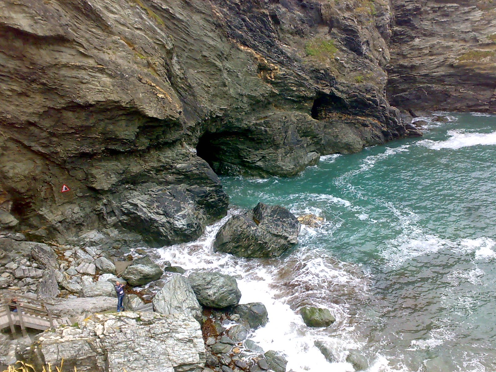
Merlin's Cave
The cavern on the west side of the Haven is known as Merlin's Cave. This is a late addition to the Arthurian legend and known since the late 19th century and publication of Tennyson's Idylls of the King. It is here, according to Tennyson, that the infant Arthur was washed up on the shore.

Today the site is managed by English Heritage and many visitors, myself included, come away with a rather negative picture of the place of where King Arthur was conceived, or born, depending which legend you are recalling. The dominant remains are those built by Richard, Earl of Cornwall, in the 13th century. The Dark Age remains are slight and, as well laid out and identified as they are, are not much to look at and hardly inspire any connections to a 6th century power base of the  Kings of Dumnonia. The so-called 'Artognou' stone found on the headland in 1998 has no connection whatsoever with King Arthur although it was much publicised as such at the time of its discovery; no doubt it was good for business. Even the name of the island may be French. And to cap it all the video display shown in the EH visitor centre will certainly dispel any hopes of finding an historical Arthur here. I left this island of disappointments feeling rather flat like so many others.


On walking back up to the village, once named Trevana, but not shy in missing the opportunity of Arthurian exploitation, they changed its name to Tintagel to match the castle, you pass the King Arthur's Arms Inn and opposite is the oldest Post Office in the country, dating to the 14th century, complete with sagging roof.  Further along the high street passing a myriad of gift shops you arrive at King Arthur's Great Halls of Chivalry.


Copyright © 2015 Edward Watson
http://clasmerdin.blogspot.co.uk/


Sources:
Alfred, Lord Tennyson, The Coming of Arthur from Idylls of the King
Paul Broadhurst, Tintagel and the Arthurian Mythos, Pendragon Press, 1992.
Colleen E Batey, Tintagel Castle, English Heritage Guidebooks, 2010.
Oliver Padel, Cornish Place-name Elements, Nottingham: English Place-Name Society, 1985.

All photographs copyright © 2015 Edward Watson


* * * 


Sunday, 25 January 2015

King Arthur's Hall: Monument or Pound?

“Arthures Hall. A place so called and by tradition helde to be a place whereunto that famous K. Arthur resorted: it is a square plott about 60 foote longe and about 35 foote broad, situate on a playne Mountayne, wrowghte some 3 foote into the grounde: and by reason of the depression of the place, their standeth a stange of Poole of water, the place sett rounde aboute with flatt stones in this manner.” (Norden, 1584)

A Moorland Enigma
The mystery of the well known monument of King Arthur's Hall on Bodmin Moor in Cornwall has been noted since it was first recorded by John Norden in 1584. The site is shown on a map of 1610 as “Arthurshall”. Debate continues whether the provenance of this moorland monument belongs to Prehistoric or Medieval times. King Arthur's Hall is a rectangular enclosure, a rare 'un-British' monument, as Burl calls it and sees similarities to the rectilinear enclosures of Brittany. It's closest relation in Britain is the rectangle of the Stonehenge Station Stones. King Arthur's Hall is an enigma. Isolated and remote, its purpose and date remain shrouded in the moorland mist.


This listed ancient monument has been damaged by livestock in the past and is now fenced for its own protection. The bank has dropped over the years and excavation may uncover further fallen stones. The interior appears to have been lined by a continuous row of large facing slabs, most now either recumbent, leaning or buried. In the centre of the south side one of the stones has been set at right angles to the bank, seemingly deliberately marking a significant feature but unfortunately the opposite position on the north bank has been disturbed. A RCHME survey in 1986 discovered traces of cobbling in the north-west corner.

King Arthur’s Hall, also known as Arthur’s Hunting Lodge, is situated in an area of open moorland, Arthur’s Downs, that extends north towards the settlements and ritual monuments of Louden Hill, eastwards towards Garrow Tor and south to Hawkstor.

The name of King Arthur is attached to a variety of landscape features; the original myth now lost to us, but it is clearly ancient and in existence in the earliest stratum of the Arthurian legend as shown in the Historia Brittonum. This 9th century document is our earliest account of a historical Arthur, the dux bellorum, the leader of battles, who fought twelve successful campaigns. Yet  contained within the same manuscript (Harlian 3859) and attached to the Historia Brittonum is the Mirabila, The Wonders of Britain, which includes a folkloric Arthur who's dog Cabal is as big as a horse and left his footprint in a rock. Another wonder mentions the ever-changing size of the tomb of Arthur's son Amr. The concept of Arthur throughout British folklore as a figure who hunted in the wild, untamed, remote parts of the landscape is apparent in Cornwall and clearly very different to Geoffrey of Monmouth's creation of an Emperor or a sub-Roman warlord. Whether there ever was such a man is open to debate but his legend endures across the wild moorlands.

There is another Cornish site known as Arthur’s Hunting Lodge at Castle-an-Dinas, near St Columb, from which Arthur rode in the hunt on Tregoss Moor; a stone in St Columb bears the four footprints that his horse made whilst he was out hunting. Nearby on Bodmin Moor, in the parish of North-Hill, are other prehistoric sites bearing the names Arthur’s Bed, and near Trewortha Farm, Arthur’s Troughs, said to be where Arthur fed his hunting dogs as recorded by the 18th Century Cornish antiquarian, Dr William Borlase, who, in 1754, said of the site:

'Round Arthur's Bed, on a rocky Tor in the parish of North-hill, there are many [rock-basins], which the country people call Arthur's Troughs, in which he us'd to feed his Dogs.'

The Hall
King Arthur's Hall is a rectangular enclosure measuring 47m by 20m, constructed  of banked earth and rough stones, of which 14 remain upright, with 25 leaning, 13 fallen and possibly another 5 visible. Modern estimates suggest there may have been as many as 138-140 stones, many of which may now lie beneath parts of the collapsed bank. An inturned stone in the south bank is set at right angles to the rest of the stones.

The earth banks are about a metre high and over 5m wide. The enclosure is aligned north-south with a gap, that may have formed an entrance, in the south-west corner. The reed-covered interior is a poorly drained, boggy rectangular hollow which usually contains a pool of water in a depression at the centre, 60cm lower than the surrounding moorland, from which the interior has been scooped out with the earth used to form the banks. The subsequent depression allows water to collect which has led to the suggestion that the gap in the south-west corner may not be ancient having been made for drainage; notably Norden's 16th century plan fails to show the gap in the south-west corner.

The enclosure is positioned on a slight ridge below the crest of the moorland plateau on King Arthur's Downs, being visible from about a mile distant but from the north only. Nearby to the south-east are a pair of ruined stone circles, 400m beyond these is the Leaze stone circle. About a mile and a half to the north are the Prehistoric settlements of Rough Tor and Louden Hill, with three further stone circles to the south.


There is evidence of substantial medieval settlement on Louden Hill with King Arthur's Hall situated near the boundary between the manors of Hamatethy and Blisland. Indeed, the Hall appears to have been present in the establishment of the manorial boundaries, which does not exclude an earlier date. On the contrary, boundaries tend to be 'one of the most permanent and ancient features of the English landscape' with Prehistoric monuments frequently used to establish boundaries in the early Medieval period.

Prehistoric Monument or Medieval Pound?
Many suggestions have been put forward for the origin and function of the Hall, ranging from a Neolithic mortuary house or enclosure, a Bronze Age ceremonial or ritual monument, a cock fighting pit to a medieval pound for stray animals. It is worth noting that a long cairn on Louden Hill was originally said to be a medieval structure and only correctly identified as prehistoric as late as 1984.

The very name 'King Arthur's Hall' is suggestive of a meeting place; thus it has been suggested that the upright granite slabs look like chairs, perhaps the place where King Arthur held counsel with his Knights? But according to a well-known website on ancient sites King Arthur's Hall has nothing to do with King Arthur.

The size of the construction of the monument and lack of original entrance tends to suggest it may be sepulchral in purpose, possibly a mortuary enclosure.  Many long barrow sites started off as small rectangular enclosures of earthen banks topped by a timber palisade, constituting a mortuary enclosure. British Neolithic mortuary enclosures were typically sub-rectangular banks with external ditches and raised platforms of stone or wood within them, thought to be used for the exposure of corpses prior to burial elsewhere. Remains of mortuary enclosures of this period are often found under long barrows. Long barrows are relatively rare in this part of the country with no more than a handful known in Cornwall. If King Arthur's Hall is a mortuary enclosure where is the sepulchre?

Prehistoric enclosures of rectangular construction are relatively rare but a similar enclosure exists in Brittany, which has been identified as a Bronze Age cremation site, and a similar ramparted construction at Lough gur in Ireland has been dated to the Neolithic. Without excavation and the absence of any archaeological finds the date and purpose of the monument must remain speculative. Recent work has shed some light on the monument but essentially King Arthur's Hall retains its mystery.


Clearance work at King Arthur's Hall conducted by members of The Heritage Trust in 2013-14 revealed a revetment wall was constructed to retain the inner bank. This brief investigation concluded that over time the earth had covered over the top of the revetment wall suggesting that the structure was originally a rectangular enclosure from which the earth was extracted and banked up on four sides, forming a sub-level receptacle with an apron between the excavated area and the banks. By removing some turf it revealed the depth of the excavated area appeared to be shallower at the perimeters and deeper in the middle. This false receptacle would have filled with water, either rising or from rainfall. Was this simply a medieval dew pond constructed for watering livestock? The continuous bank would make that seem unlikely.  So we are back to the possibility of a prehistoric enclosure for ritualistic use.

King Arthur's Hall may have experienced several construction sequences over time; Burl suggests the enclosure may have started life as a 'megalithic rectangle' similar in appearance to the monument at Lanveoc, Finistere on the Crozon peninsula in Brittany, also aligned to the cardinal points but with the longer sides arranged east-west.

The banks of King Arthur's Hall may have been added later in the medieval period and the enclosure adapted to form a pound for stray animals. But the apparent lack of any portal arrangement considered with the 'awkward' siting of the entrance in the south-west corner of the enclosure argues against King Arthur's Hall being originally conceived and constructed as an animal pound, which, from the prehistoric period onwards, were commonly constructed using drystone walling techniques – not megalithic stones.

The construction at King Arthur's Hall is unusual in that typical prehistoric earthen enclosures tend to have the bank created from the spoil of the ditch. There is no evidence of a ditch here, as noted above the earth banks have been created by scooping out the centre to a depth of 60cm. This technique of scooping material out for the banks was widely used in the construction of henges in Ireland, but almost unknown in Britain. Mayburgh henge in Cumbria is another rare example in Britain.

In parts of King Arthur's Hall where the stones remain in place, presumably in their original position, they appear to have been arranged alternately low flat-topped slabs and taller pillars 'like the parapet of a disjointed battlement'; an arrangement that would be pointless in an animal pound. Burl considers the stones are embellishments and notes a similar observation in the West Kennett Avenue at Avebury where paired yet contrasting stones (male and female?) are used in prehistoric ritual monuments. The stones at  King Arthur's Hall rest against the bank rather than revetting it as in the Grange henge in Co. Limerick, Ireland.

It would appear King Arthur's Hall is not typical of British prehistoric construction and therefore we do not recognise it as such. Instead of assigning the monument to the  medieval period as an animal pound we need to recognise it as a Neolithic monument constructed using a conglomeration of prehistoric methods taken from Ireland and Brittany.


Copyright © 2015 Edward Watson
http://clasmerdin.blogspot.co.uk/


Notes & References
John Norden, A Topographical and Historical Description of Cornwall, 2nd edition, 1728.
Diana Coles, 'King Arthur's Hall; Megalithic Monument or Mediaeval Pound', 3rd Stone magazine issue 39.
Aubrey Burl, Great Stone Circles, Yale, 1999.
Aubrey Burl, The Stone Circles of Britain, Ireland and Brittany, Yale, 2000.
The De Lank to Lowermoor water main, Bodmin Moor, Cornwall, commissioned by South West Water and English Heritage and carried out by the Cornwall Archaeological Unit (now Historic Environment Projects), Cornwall Council. Draft October 1994, revised March 2011


> CL <


* * *

Monday, 12 January 2015

Anglo Saxon Coin Hoard Found in Buckinghamshire

One of the largest hoards of Anglo Saxon coins ever found in Britain was discovered on farmland in Lenborough, Buckinghamshire just before Christmas 2014 during an annual end-of-year rally for members of the Weekend Wanderers Detecting Club. The find has been sent to experts at the British Museum for analysis.


Metal detector Paul Coleman found a lead-lined container buried two feet under ground containing more than 5,000 silver coins made in the reigns of Æthelred the Unready (978-1016) and Cnut (1016-1035). Mr Coleman knew they had stumbled across something significant when they picked up a signal the size of a manhole cover. The coins were hidden inside a lead bucket with the top folded over. If the coroner rules the coins are legally treasure, as expected, he could be in line for a six-figure payout which he will share with the landowner.

It is thought that the coin hoard could be connected to a mint established by Æthelred at Buckingham only 15 miles away from the find site, one of 70 active at the time, including Winchester, London and York, during a remarkable period of history which pioneered the mass production of the solid silver currency in England.

Æthelred became King of England around the age of ten following the murder of his half-brother Edward II in 978 at Corfe Castle, Dorset, after reigning for just three short years. Edward was the eldest son of King Edgar but was not his father's acknowledged heir and his succession was disputed.

Æthelred was not generally suspected of being directly involved with his brother's murder, but the attendants of his household certainly were with many, such as the chroniclers John of Worcester and Henry of Huntingdon, pointing the finger of suspicion firmly toward his mother Ælfthryth. The suspicious circumstances of Æthelred ascension to the throne, and the growing legend of St Edward the Martyr, made it difficult for the new king to rally the nation behind him against the raiding Danes which had plagued his reign from the 980s onwards.

Æthelred failed to win or retain the allegiance of many of his subjects  and was given the epithet 'Un-raed', often interpreted as 'Unready' taken to mean 'no counsel', but actually a miss-translation of the Old English for 'bad-counsel', seemingly a reflection of the poor advice he received during his reign, and a deliberate pun on his first name meaning 'noble counsel', typical of the royal House of Wessex.

On St Brice's Day 13 November 1002, Æthelred ordered the massacre of all Danes in England to eliminate potential treachery. Gunhilde, sister of Sweyn Forkbeard, King of Denmark, was said to have been among the victims. Her death is thought to have been a primary motive for Sweyn's invasion of western England the following year, in which he campaigned throughout Wessex and East Anglia in 1003–1004.

The Buckingham mint remained active during the time of Cnut, with Æthelred pushing his people hard to raise Danegeld (literally 'Danish tax'), to pay tribute to the Danes. But the pay-off's failed to stop the Danish raids and he fled to Normandy in 1013 when Sweyn dispossessed him.

Following Sveyn's death in 1014 Æthelred returned to England but died  two years later in April 1016 during the invasion of Cnut, the son of Sweyn, that sailed up the Thames with a force of more than 10,000 men. He was the first king of England to be buried at St Paul’s Cathedral. Cnut consolidated his position by marrying Æthelred’s widow Emma. Cnut's empire now stretched across the sea to Denmark, and even extended his rule into Norway and parts of Sweden, known as the North Sea Empire.

The lands of Cnut the Great 1016–1035 (Wikimedia Commons)
Æthelred's oldest surviving son, Edmund Ironside, led the English against the Danes between 1014 and 1016. Following victory for Cnut at 'Assandun' in Essex on 18th October 1016, Edmund conceded all territory north of the Thames while his realm was reduced to just Wessex. But when Edmund died barely two months later in November, Cnut inherited the whole kingdom.

We will never know who buried these coins during these turbulent times or why they never recovered them. However, it is difficult not to speculate on the context of the Buckinghamshire hoard being entangled in Danegeld payments and Danish incursions.

Only half of the 5,251 coins of the Buckinghamshire Hoard have been cleaned so far but all have proved to be in excellent condition and, as coins of the two kings known in the hoard, Cnut and Æthelred, rarely fall below £200 per coin, the total value of the find could be around £1 million.

In July 2009  metal detector Terry Herbert discovered the largest ever hoard of Anglo Saxon treasure in a field at Hammerwich, near Lichfield in Staffordshire. Consisting of more than 3,500 gold and silver warrior artefacts, the ‘Staffordshire Hoard’ was valued at £3.3 million.


*


Sources:
Buckinghamshire ancient coin hoard find 'unprecedented' – BBC News 03 January 2015
Metal detecting club finds Anglo Saxon hoard – Museums Association 07 January 2015


* * *

Monday, 29 December 2014

Vikings: Violent Raiders or Extraordinary Explorers?

The Norsemen's Fury 
Anglo Saxon England shuddered on 8th June 793 AD when a raid by heathen men from across the sea brought plunder and slaughter on the island monastery at Lindisfarne. The raid off the coast of northern England signalled the beginning of the Viking Age, a period of major change across Europe in which the Norsemen are primarily remembered as vicious marauders.

In 843 a Viking raiding party sacked the city of Nantes on the Loire River while the people of the town were observing the festival of Saint John. The Norsemen entered the city unopposed and slaughtered the inhabitants. The Chronique de Nantes records the slaughter:

“After they had disembarked some of them climbed the walls of the city using ladders, others penetrated the cloisters. No one could prevent their entry. The entered the city on the holy festival of St. John the Baptist. The Bishop of the City was Gohardus, a simple, handsome and God-fearing man, with whom all the clergy and monks of the monastery were gathered… 

….The Vikings slew the entire multitude they found there without regard to age or sex. They cruelly killed the priest and bishop Gohardus who died saying ‘Sursum corda’. All the other monks, whether they were in the church, outside it, or at the altar were put to the sword and disembowelled…”

Much of the Viking's exceptional achievement's are over-shadowed by their bloodthirsty reputation, indeed the very word “viking” has become synonymous with a violent raider. However, a growing number of scholars believe the Vikings were no more bloody-minded than other warriors of the period.

In his new book The Age of the Vikings (Princeton University Press, August 2014) Yale historian Anders Winroth argues that the Vikings acted not much differently from other European warriors of the period, citing the mass execution of  4,500 Saxon captives on a single day in 782 by Charlemagne who is now “heralded as the original unifier of Europe.”

Winroth maintains the image of the Norsemen is too often distorted by medieval and modern myth, suffering from bad public relation, in part because they attacked a society more literate than their own, and therefore most accounts of them come from their victims. Moreover, because the Vikings were pagan and often attacked religious houses they played into a Christian story line that cast them as an evil, demonic force. In his book Winroth carries out a sweeping new survey to show such exaggeration was often a feature of European writings about the Vikings.

The extraordinary Viking expansion from their Scandinavian homelands created a cultural network stretching across four continents from the Arctic Circle and the lands of the North Atlantic to the Mediterranean and the Caspian Sea.

In answering the question "Vikings: Violent Raiders or Extraordinary Explorers?" we should consider the evidence provided by the distant travels of these remarkable seaborne voyagers which continues to be discovered and 2014 has not disappointed.


Vikings: Life and Legend Exhibition
In March the Vikings: Life and Legend Exhibition opened at the British Museum in London. The first major exhibition on Vikings at the British Museum for over 30 years featuring many new archaeological discoveries and objects never seen before in the UK alongside important Viking Age artefacts from the British Museum’s own collection. The main attraction at the exhibition was the longest Viking ship ever discovered. The 37-metre-long warship, known as Roskilde 6, was powered by 40 pairs of oars and dated to  around 1025, was excavated from the banks of Roskilde fjord in Denmark in 1997.

Harald Bluetooth’s fortress found?
A team from Aarhus University announced in September the discovery of a new Viking fortress for the first time in 60 years. The fortress is constructed as a ringfort in a field belonging to Vallø Manor on the east coast of Sealand in Denmark, is with some certainty, the fifth of it’s type, a so-called “trelleborg” from Viking times. The trelleborg fortresses are unique for Denmark. Carbon-14 dating has confirmed the fortress was built in the period between the year 900 and the beginning of the 11th century, leading to speculation that the site was one of Harald Bluetooth’s fortresses.

Viking Hoard found in Dumfries and Galloway 
In October the Herald Scotland announced the discovery of more than 100 objects of Viking treasure on church land at an undisclosed location in Dumfries and Galloway in one of the most significant finds of its kind ever made in Scotland. The hoard unearthed by metal-detecting enthusiast Derek McLennan included artefacts of gold and silver from a wide geographic area that includes Ireland, Scandinavia, and central Europe and possibly the largest silver Carolingian pot ever discovered.

Feasting Hall discovered in Denmark
The December issue of the journal Archaeological Prospection published news of the identification of a major Viking  feasting Hall near Vadstena in Sweden. The hall measuring almost 50 metres in length was located by Archaeologists from Stockholm University and Umeå University. The location where the hall was found has long seen as a burial mound, the Aska barrow, but mapping with ground penetrating radar revealed that it is a foundation platform for a large building most likely dating from the Viking Period. The hall was probably the home of a royal family whose rich graves have previously been excavated nearby.

Viking Women raiders
A study of Norse DNA suggests that Viking men took significant numbers of women with them in their longboats when they sailed to places such as the Scottish mainland, Shetland, Orkney and Iceland. Researchers analysed maternally inherited genetic material, known as mitochondrial DNA, extracted from 80 Viking skeletons unearthed in Norway. The result suggest that Norse women played a central role in the Viking settlements established in Britain and other parts of the North Atlantic contradicting the stereotype of male-only raiding parties with an unhealthy appetite for rape and pillage.


Evidence of Viking Metalworking in Canada
The belief that Viking seafarers travelled from Greenland to parts of Arctic Canada has been confirmed by the discovery of Norse artefacts in mainland Canada and the Arctic islands over the past several decades. The discovery of metalworking artefacts could be the earliest evidence of high-temperature non-ferrous metalworking north of Mesoamerica. Analysis of a broken stone vessel discovered on Baffin Island has shown it to be a crucible with traces of a bronze on the inside used for metalworking. It is thought the crucible may have been brought to Canada by Norse seafarers travelling from Greenland or Iceland.

Spanish Vikings
Generally there is only a vague knowledge that the Vikings went to Spain. There are written accounts of the Vikings raiding in northern Spain from around 840 until the 11th century, but, archaeologically, absolutely nothing has been done. In March 2014 a number of Viking anchors were washed ashore in a storm at Galicia in Northern Spain. On the beach where the anchors were found there was a big mound which locals thought might have been a motte-and-bailey construction, which was used by the later Vikings in France. But it is suspected this mound was a longphort – a Viking construction only found in Ireland during the early Viking age, and very similar to English Viking camps, where they would winter, after taking over the harbour.

First Vikings to make the trip to the British Isles
In an article published by the journal Internet Archaeology, Heen Pettersen writes that foreign objects found in burial sites in mid- and western Norway coincide with the first known Viking raids in Lindisfarne, England in 793. (Science Nordic December 2014)


Copyright © 2014 Edward Watson
http://clasmerdin.blogspot.co.uk/


* * *


Tuesday, 9 December 2014

Mythmaking & Mapmakers

King Arthur & the Northern Enchantment Part IV

The Mapmakers
The Flemish cartographer Gerardus Mercator (1512-1594) is well known for his innovative mapping technique based on cylindrical projection first used on his wall chart of 1569, later known as the Mercator Projection accordingly and still in use today on navigational charts. Mercator's map provided a major breakthrough in the nautical cartography of the 16th century by maintaining an accurate ratio of latitude to longitude.

Today, in our modern world with maps produced from satellite imagery and modern printing technology, these early charts present a very strange world view to us. To the 16th-century Europeans the northern polar region was as distant and fantastical as another world; tales of lands inhabited by pygmies, congealed seas, perpetual daylight, whirlpools, a realm of ice that pulled at the lodestone.

Concepts of the known world, influenced by religious views, dominated European maps during the Medieval period with Jerusalem typically shown at the centre. These early maps were, of course, drawn and illuminated by hand, with little duplication and extremely limited distribution. Reports from returning explorers provided vital information for the early map makers. From the beginning of the 12th century Viking explorations of the North Atlantic fuelled the Norse Sagas and began to be incorporated into world maps but the view of the northern polar regions remained shrouded in Arctic mist.

Mercator's north pole
The legend on Mercator's 1569 map claimed the information he based his representation of the Septentrional (northern) regions was gleaned from the accounts of the travels of Jacoben Cnoyen who quoted 'historical facts' of Arthur the Briton from the Gestae Arthuri, and another work written by an English friar from Oxford who had travelled in the far north in 1360 and recorded what he saw in a work called the Inventio fortunata. Unfortunately all these accounts are now lost and all we have of  the contents is recorded in Mercator's letter of 1577 to the Elizabethan geographer John Dee.

The account of the Septentrional regions recorded in the Inventio depicted a great black rock, the Rupes Nigra, at the top of the world with four indraughts which had the force to swallow whole ships, dividing four islands within a mountain range at latitude 78' like a jagged wall around the Pole.  Evidently the Inventio coloured Mercator's view of the northern polar regions as shown on his 1569 wall map and persisted to the first edition of his atlas map of the Arctic, published in 1595, a year after his death, which shows four complete islands with a solid coastline, marking a significant leap in Arctic cartography. Yet, although the author of the Inventio may have claimed to have travelled northwards from latitude 54' he cannot have actually reached the North Pole; the Arctic world he describes is far from the reality we know today.

At this time no explorer had been anywhere near the North Pole, and today we view the ring of islands shown surrounding the North Pole as pure fantasy derived from a mythical concept like something from Tolkien's Middle Earth; yet this interpretive image of the Septentrional Islands and Indrawing Seas depicted in the 14th century Inventio Fortunata persisted for a remarkable length of time and influenced early polar geography from the accounts of  Martin Behaim's globe (1492), Johannes Ruysch's world map (1507), Mercator's wall chart (1569) persisting through to the 17th century in Peter Heylin's 'Cosmographie' (1657).

The detail of the northern polar regions depicted on Behaim's globe shows what he presumed to be the northern edge of the Eurasion continent, the 'edge of the world' as shown on many other maps of the time. The northwest part of Behaim's Arctic coast and that of Scandinavia appear to be based on interpretations of Claudius Clavus. But there is no known precedent for Behaim's central Arctic coast.

In the 2nd century AD the Greek geographer Ptolemy advanced a scheme of cartographic projection that allowed flat maps to account for the curvature of the Earth that he had perfected form his predecessor Marinus of Tyre and acknowledges his great obligations to him in his work 'Geographia'. It wasn't until the rekindling of interest in Ptolemy during the Renaissance that a French cardinal Gulielmus Filiastrus had a Latin translation made of the map captions in his work. The Latinized maps were appended to a 1407 translation. The Filiastrous Ptolemy included a textual description and map of Scandinavia, a region known to Pliny and Mela but with insufficient detail as to be enclosed in local maps.

The Danish cartographer Claudius Clavus was considered a leading authority on the regions of the north at this time, and probably the first to put Greenland on the map with an outline, which was included in the Filiastrous Ptolemy of 1427. From documents written by Nicolas Germanus and Henricus Martellus it seems Clavus visited Greenland in 1420 around the time that Norse settlements in Greenland had come to an end after five hundred years. Clavus's sources were probably Norse but he admitted that some unknown areas, such as the landmass linking Greenland to Scandinavia, were based on conjecture.

In 1558 a book entitled De I Commentarii del Viaggio [The Discovery of Frisanda, Elslanda, Estotilanda and Icaria; Made by Two Brothers of the Zeno family: viz Messire Nicolò, the Chevalier, and Messire Antonio; with a Map of the said Islands] was published by a Venetian nobleman named Nicolò Zeno that claimed an accompanying map was made by his ancestors, the brothers Nicolò and Antonio Zeno, in 1380. The book claimed the map illustrated the lands of the North Atlantic, and some argue North America, discovered by the Zeno brothers a hundred years before Columbus set foot on the New World. A third brother from this distinguished family was the naval hero of the Mediterranean, Admiral Carlo Zeno (d. 1418). The younger Nicolo’, great-great-great-grandson (?) of Nicolò senior, claimed he had an ancient family manuscript which he, as a child, had torn to pieces. Realising that the document contained important information on the explorations of his family he attempted to reconstruct the presumed content of the manuscript by pulling together quotations from letters found in his family house that told the story of Nicoló the navigator who was shipwrecked near the Island of Frislanda while voyaging to England.

The Zeno map (Wikimedia commons)
He was hired by the locals to command the fleet of Frislanda. Later Nicoló wrote a letter to his brother Antonio in Venice inviting him to join him in Frislanda where they enjoyed adventures together until four years later when Nicoló died, c.1398. Antonio stayed in Frislanda for a further ten years before he returned to Venice.

Writing from somewhere in the North Sea just before the time of his death the elder Nicoló claimed that twenty six years previous (c.1372) four fishing boats put to sail and were driven across the sea for several days by a heavy storm. They came to an island called Estotiland, a rich country, abounding in gold (or copper?) and plentiful in all good things, with immense woods, whose people grew corn and drank beer, lying more than a thousand miles westward from where Nicoló wrote. They traded with Greenland, importing furs, brimstone and pitch.

Antonio describes a journey he took to Greenland in which he saw a monastery situated by a hot spring at an unknown location. The waters were used to heat both the monastery and the friar's chambers. Today there is still an active thermal spring at Uunartoq Island which would have been in the Norse Eastern Settlement of Greenland where a cloister is known to have existed. Today a spa bathtub constructed from boulders can be found there with the oldest traces dating back over a thousand years to the time of Norse settlement. Nearby the remains of a Benedictine convent dedicated to Olaf the Holy, King of Norway 995-1000 who baptised Leif Ericson, was located in 1932. It was later identified as the Norse religious house mentioned by Ivar Bardarson in his Description of Greenland, a report written for the bishop of Bergen between A.D. 1341-60. Bardarson was the bishop's envoy and probably sent to the Greenland settlement to collect taxes for the church. By odd coincidence this is around the same time that the friar from Oxford is said to have visited the north and penned the Inventio Fortunata.

The remains of a compass, known as the Uunartoq disc, were found in the convent in 1948. Initially thought to have been a decorative object but other scholars have argued the wooden disc was an important navigational tool used by the Vikings in their 1,600-mile-long sea journey almost directly west from Norway to Greenland. It is thought the Vikings could have used a pair of crystals known as sunstones, in conjunction with the wooden disc, to locate the sun after sunset and pinpoint the position of the sun below the horizon, enabling them to navigate the North Atlantic along a nearly straight line.

According to the Icelandic Sagas the first Norse settlements in Greenland were founded by Erik (The Red) Thorvaldsson, father of the famous Icelandic explorer Leif Ericson, acknowledged as the first European to land in North America nearly 500 years before Christopher Columbus. Erik the Red's father had been banished from Norway for manslaughter and sailed West to Iceland. Later Erik the Red was exiled for three years by the Icelanders as he too had committed "some killings" c.982. According to the Saga of Erik the Red, he spent his three years of exile exploring a mysterious and little-known land. He rounded the southern tip of the island and sailed up the western coast identifying habitable lands.

After his exile he returned to Iceland with enticing tales of this new land, naming it 'Greenland' to make it sound more attractive than 'Iceland'. Erik returned to Greenland in 985 with the first colonists in 24 boatloads but only 14 completed the journey, the others boats were either forced back to port or lost at sea. Erik established two colonies on the southwest coast of Greenland; The Eastern and Western Settlements.

Nicoló Zeno and the fishermen remained five years at Estotiland. No one could understand their language except an interpreter that spoke Latin who had also by chance been cast on that island. The king of Estotiland sent them with twelve boats to a land to the south they called Drogeo who's people are described as such that they are probably North American Indians.  Nicoló and the fishermen spent thirteen years on Drogeo among the natives before returning to Estotiland. It seems likely the inhabitants of Estotiland where Norsemen and the island was actually Newfoundland which is due west of the North Sea by 'more than a thousand miles' and the land called Drogeo may have been Nova Scotia. Finally Antonio sailed home to Venice with their story.

The North Atlantic from Sebastian Munster's Cosmography
It is from these letters that the younger Nicoló claimed to have extracted details of his ancestors’ voyages to Engroneland (Greenland) and distant islands of Frislanda, Icaria, Drogero, Estotiland and Estland, in the northern Atlantic as depicted on the Zeno map in remarkable detail. Many of these islands were printed on maps for centuries; in the 16th century the accounts of the brother's voyages clearly influenced Mercator who included the Zeno geography in his world map of 1569, followed closely by Abraham Ortelius in his map of the Northern Atlantic in 1573.

Following the Zeno geography Mercator included Frislanda in a separate inset on his 1595 map of the North Pole which led to considerable confusion in the mapping of Greenland and Baffin Island in the following centuries. In 1576 the explorer Martin Frobisher took a copy of the Zeno map with him on his voyage to the Arctic. When Frobisher reported sight of land which he believed to be Frislanda, he claimed the island for England in the name of Queen Elizabeth. He had actually sighted the coast of Greenland, consequently when he got to Baffin Island he thought he was at Greenland, and so the reports of all his explorations around Baffin Island were ascribed to Greenland. Thus it was that for many years "Frobishers Strait" was put at the southern tip of Greenland rather than on Baffin Island. He had initially thought the channel, later to bear his name, was in fact the fabled Northwest Passage with the mistaken notion that the land bounding the strait to the south was America, and that to the north was Asia. It wasn't until 1861 that it was realised it was actually a bay at the southeastern corner of Baffin Island.

After Mercator, one of the most influential geographical works of the 16th Century was Sebastian Munster's Cosmography. The 1579 German  issue of Munster's Cosmography included an early regional map of Scandinavia, Iceland, the Baltic and the North Sea regions, based upon Abraham Ortelius' map first issued in 1573. Again the fictitious islands of Frislanda and Icaria are shown near Iceland, and further west Estotiland is shown as a part of North America and other mythical features such as the islands of St. Brendan and Brazil. No wonder explorer's like Frobisher were confused.

However, the Zeno account was accepted as genuine enough and for a long time considered one of the most important charts made in the late 14th century, during the following centuries Frislanda was included by most cartographers and even appeared as late as Lotter's 18th century map. But as knowledge of the North Atlantic advanced many of the lands depicted in the Zeno map proved to be fictitious and simply did not exist.

Two years after Mercator's death in 1596 the Dutch Arctic explorer and cartographer Willem Barentsz in searching for a Northeast passage along the coast of Siberia discovered and mapped Spitsbergen (shown as "Het Nieuwe Land" Dutch for "the New Land") for the first time and rounded the northern tip of Nova Zembla. This break-through achievement redefined the cartographic perspective of the region, for these newly discovered islands were well into the latitudes where Mercator had mapped his four Arctic lands. In subsequent decades all trace of Mercator's four circumpolar islands, the Rupes Nigra, and the Arctic maelstrom had vanished from maps of the northern regions.

Willem Barentsz's map of the Northern Polar region
 Mercator's four islands around the pole have gone but Frisland is still there
In 1898 Frederic W. Lucas published a scathing criticism of the Zeno account entitled 'The Annals of the Voyages of the Brothers Nicolò and Antonio Zeno, In the North Atlantic About the End of the Fourtheenth Century and the Claim Founded Thereon to a Venetian Discovery of America; A Criticism and an Indictment'. Lucas argued that the Zeno narrative and its accompanying map was nothing short of a complete fabrication extracted from several Renaissance maps and works, including representations of Iceland taken directly from Olaus Magnus which the author of the Zeno narrative utilised to represent an enigmatic new land which some have interpreted as America. As a direct consequence of Lucas' criticism, today the Zeno map and narrative is regarded to be at best of doubtful authenticity if not an outright hoax.

No copy of the Zeno map is known to exist prior to its publication in Nicolò Zeno’s 1558 book and conveniently, some might say, the author claims he destroyed the original text as a child so we only have the 16th century edition. The authenticity of the Zeno map seems to be betrayed by its very accurate depiction of Greenland which is significantly superior to other 14th century maps, and appearing nearly identical in shape and orientation to the Clavus-derived 1467 map of Nicolaus Germanus.  Indeed, modern scholars have concluded that the Zeno map is derived from a compilation of several earlier maps, including Olaus Magnus’ Carta marina, printed in Venice in 1539 and derivatives of Claudius Clavus’ early map of the North c.1427.

The fact that the likes of respected 16th century geographers such as Mercator and Ortelius could be taken in by these representations of the northern polar regions, such as the Zeno brothers and the Inventio Fortunata, underlines what little knowledge educated Europeans actually had of the Arctic regions and hardly surprising that explorers were confused when on the ocean.

Quite simply unchartered lands (Terra incognito) beyond the edge of the map were based on mythological perceptions and Polar maps at the extremes given fabulous descriptions.


Copyright © 2014 Edward Watson
http://clasmerdin.blogspot.co.uk/


Notes & References
HR Holand, An English Scientist in America 130 Years before Columbus, Transactions of the Wisconsin Academy of Sciences, Arts and Letters, pp. 205-219, Volume XLVIII, 1959. Holand argues that the Oxford friar who wrote the Inventio Fortunata must have been in Hudson Bay.
James Robert Enterline, Erikson, Eskimos, and Columbus: Medieval European Knowledge of America,  Johns Hopkins University Press, 2004.
Robert McGhee, The Arctic Voyages of Martin Frobisher: An Elizabethan Adventure, McGill-Queen's University Press, 2006.
Fred W. Lucas, The Zeno Voyage: Anatomy of a Hoax, edited by Jason Colavito, CreateSpace Independent Publishing Platform, 2013.


* * *